
The prized blue ribbon encircling Greater Peoria is key to improving the water quality of the Illinois River and beyond.
Let us swirl through the galaxy of time, to the time before time, as we explore the watershed of Kickapoo Creek. The more we understand about its natural history, geology, flora and fauna, the more our own human history makes sense. Then we may turn our attention to the future of this vital tributary as a potential resource for cleaner water, recreational opportunities and a healthier planet. What we are doing here on the Kickapoo is potentially a new model for dealing with nutrient runoffs into the Greater Mississippi Watershed. Let us travel…
Cycles of Life
As the Milky Way galaxy makes its way through the cosmos and the Earth spirals around a circling sun, a quiet creek gurgles through a glacial valley encircling the modern metropolis of Peoria, Illinois. Kickapoo Creek, with its many tentacled tributaries, embraces nearly three fourths of the broader Peoria area, with the Illinois River providing the other shore.
Let’s drop down into this valley, with the ancient sandstone bluffs of Rocky Glen standing high above Horseshoe Bottoms. There are oak-hickory remnants on the hilltops—some of these trees older than the metropolis itself. There are a few small patches of prairie along the railroad right-of-way and in nearby graveyards. And where the creek was not straightened (ironically, under a stretch of I-474 not far from the airport), where the shoreline was not denuded, nor the field drained and tiled, you might even find an endangered rainbow darter swimming about, or a monkeyface clamshell hiding in Kickapoo Creek’s musical rivulets.
Look closer still, on a microbiological level, and a biochemical connection becomes more clear. The carbon, nitrogen and phosphorous—the building blocks of the myriad of lifeforms—was, and could be again, part of the crunch of those corn chips you ate last night alongside the tamale at your favorite Mexican restaurant. Pause and consider: the molecules that are currently you will soon leave and cycle back out into the broader world. Within a few years, most of what is you will be made of entirely new cells. Now reconsider: when we flush yesterday’s dinner down the pipes, do we see this as waste, or as part of this miraculous circle of ongoing metamorphosis?
How we think about the most basic chemical elements of life influences the choices we make regarding waste management. In nature there is no waste, and we are undeniably a part of these cycles.
Hidden Stories in the Land
An important part of the process of restoring the watershed is a deep dive into the land’s natural history. But we must also wade through more recent human history: the agricultural, industrial and other human uses of the land. A plat map is a good place to start.
Similar to the way you might study your family tree, the landscape itself has a genealogy. Let this phrase settle in: landscape genealogy. The names on the map begin to tell stories. Titles and deeds speak of the stories hidden in the landscape.
From Kickapoo Creek north to Peoria Heights, much of this area was settled by the earliest Native Americans, from hunter-gatherers following herds of wooly mammoth and mastodon to more established agricultural villages. Why, just south of Kickapoo Creek the skeleton of an ancient bison was found with a fragment of a spear broken off in its rib! There are three layers of civilizations who built mounds: the early Woodland, Hopewell-Adena and Mississippian Mound builders. Each civilization built larger mounds, larger cities and more elaborate cultures, with trading routes reaching further and further across the continent.
When the French explorers arrived, there was a large village of the Peoria band of the Illiniwek Confederacy. The French established trade relations and over time built a small town, a fur trading post, a warehouse, a church and several houses along the shore of the river.
During the War of 1812, though the French were allies, our territorial governor Ninian Edwards and his militia forced out the native people and burned the French village. They arrested the men and abandoned the French women and children. Potawatomi Chief Gomo rescued the women and children and took them to St. Louis so they could be reunited with their husbands and fathers.
This launched a series of lawsuits in which the French sued the Americans, seeking retribution. These cases were tied up in the courts for more than 50 years. Norman Purple and Abraham Lincoln were friends, but they represented opposing sides in some of these cases, while working together on others. Eventually the state Supreme Court decided in favor of the French land claims, and the Americans had to pay retributions.
One name stands out on the old plat map: Clarissa Wren. Her husband Aquila Wren had an affair and sued for divorce, but died before it was settled. Clarissa brought the case to the Illinois Supreme Court with Abraham Lincoln as her lawyer. Lincoln argued that this was not a divorce case; Clarissa, a widow, deserved a portion of her husband’s estate. When Lincoln won the decision, he pushed open this crack in the door and helped the courts re-access the original divorce. This landmark case was the first time a woman had any rights in a divorce in Illinois history. Clarissa Wren’s name on the plat map affirms Lincoln’s success as a lawyer.
Clarissa’s property is within the floodplain of the Illinois River and Kickapoo Creek—near where a landmark case for biological remediation of nutrient runoff into the river is being developed. How beautiful it is when we understand how history and ecology whirl together to map out a clearer path to a better future!
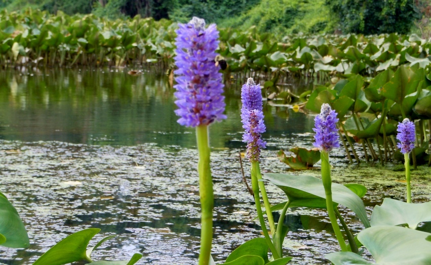
The native Pickerelweed, pictured above, can be found across Illinois in the shallow water of marshes, swamps, bogs, ponds, and protected areas of rivers where the water is slow-moving—but its population has declined due to habitat destruction. Improving the water quality of the Kickapoo Creek watershed would help increase the diversity of wildlife habitats and species.
A Watershed-Based Solution
Let us turn towards the future. The goal is quite simple: we are developing wetlands as filters to sequester carbon, reduce nitrogen and phosphorous runoff, and improve the overall water quality of the Illinois River. This will have a direct impact on the Mississippi, and if replicated in other tributaries, could have a large impact on reducing the dead zone in the Gulf of Mexico—no small matter.
In the same way that air polluters can purchase carbon credits to offset their environmental impact, an effort is underway to develop and sell nutrient runoff credits. If we can show a measurable impact on the water quality of the Kickapoo Creek watershed, we could sell these credits to sewage treatment plants to help them remain compliant with EPA standards.
As Doug Blodgett of The Nature Conservancy said, “We are doing seven great things for the environment for less than the cost of one.” We are creating a better habitat for wildlife, increasing the diversity of habitats and of species. We are creating recreational opportunities for hiking, canoeing and bird watching. We are improving the quality of life for the people of central Illinois. We are having a direct impact on the Illinois and Mississippi rivers. And we are doing all this for much less money than it would cost to mechanically filter Peoria’s sewage.
This idea was launched about a year ago by a pre-eminent wetlands restorationist, Dr. Donald Hey, and his team with the Wetlands Research Institute. A conversation among stockholders led to a tour of the watershed, which included some Peoria Park District property, the Peoria sewage treatment facility and Wildlife Prairie Park. A good map reveals a few thousand acres of property along the creek are already in public hands, including Wildlife Prairie Park, Sommer Park, Jubilee State Park, Horseshoe Bottoms and Rocky Glen.
“We are meeting with the Illinois EPA to get approval for this nutrient credit system,” says Dr. Hey. “Our goal is to reinstall the pre-settlement pool and riffle structure originally built by the American beaver.”
Bradley University, the University of Illinois and Northwestern University are on board to assist with a scientific analysis of the current status, and to monitor and measure the positive environmental impact.
“This is a potentially profitable venture in that we can sell environmental credits in much the same way that we are reducing air pollution by selling carbon credits,” adds John Holmberg, who is managing the project’s capital investment. “We are raising our capital privately because the investment community believes in this project.”
Why is this project important to Peoria? Brian Johnson, director of the Greater Peoria Sanitary District, waxes poetic: “Having a way to clean wastewater is critical for our partner municipalities to attract new industries and build strong communities. The public treatment plant run by our staff… is known for its well-run and sustainable operations, while constantly evaluating new innovations which provide a benefit to its customers. One such innovation is watershed management.
“As current wastewater treatment processes reach technological limits, reaching the next generation of water quality limits in economical and common-sense ways will require watershed-based solutions. Strong, adaptive leadership and collaboration across many stakeholder groups will be critical for success. If anyone can do this and become a model for the rest of the nation to follow, it’s Peoria.” iBi
If you would like to join this watershed restoration effort or keep abreast of upcoming developments, contact Brian “Fox” Ellis at [email protected].